| Marin Conservation League | 175 N. Redwood Dr., Ste. 135 | San Rafael CA 94903 | Tel 415.485.6257 | Fax 415.485.6259 Email Us. |
 |
ENews Article 2
2012 - A year for anniversaries
2012 is a record year to celebrate significant anniversaries in the history of all four land management agencies in Marin—National Park Service (Point Reyes National Seashore and the Golden Gate National Recreation Area), California State Parks, Marin Municipal Water District, and Marin County Parks—as well as the history of Tamalpais Conservation Club, Marin’s oldest conservation association. Events to commemorate their centennial or decade anniversaries are scheduled throughout the year--click on each agency's logo to see an updated schedule of events.
Anniversaries may mark significant milestones, but they don’t reveal the years of dedication or the collective efforts of thousands of volunteers that it takes to bring the initial idea of protecting special lands to successful fruition. Often an official dedication is just the beginning, or at best a midpoint following years of work at both grassroots and political levels, followed by extended campaigns to obtain the funds needed to fulfill the vision. That pattern is evident in all of the following stories.
Back to topMMWD and TCC: 100 years of conserving a watershed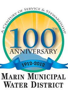
Marin Municipal Water District’s was the first major accomplishment in public land conservation in Marin County. With the exception of Muir Woods National Monument, dedicated in 1908, and a few municipal ball fields, there were no public parklands in Marin County in the early 20th century. MMWD was created by referendum in 1912. In 1915 voters approved the $3,000,000 bond measure that enabled purchase of 10,700 acres of watershed that would eventually become the 21,500 acres now owned by the district. The founding of Tamalpais Conservation Club (TCC) followed MMWD’s within a few months.
MMWD and TCC have different interests in the Mt. Tamalpais watershed but their 1912 origins are linked. For a growing Marin population, water was essential. MMWD was able to consolidate numerous private water supply companies into one public utility. At the same time, hikers who swarmed every weekend by ferry and train to Mt. Tamalpais were disgruntled that private water company lands were closed to the public. For TCC and other hiking clubs, the district’s ownership of the watershed promised to open up a “wilderness park.” As a consequence, TCC not only supported the District’s bond measure but also cooperated in trail maintenance, litter cleanup, fire patrol, and building fireplaces. TCC assumed the permanent mantle of “Guardian of Mt. Tamalpais.”
MMWD History Project. Jack Gibson, a Director of MMWD and one-time history teacher, found his interest rekindled about ten years ago when he saw the need for a history of the first municipal water district chartered in the State. He enrolled in a course in the environmental history of the U.S., with the result that Jack hopes to complete his Master’s thesis late this year on the creation of MMWD up to the first delivery of water in 1916. He also has just completed an illustrated history of the district for Arcadia Press, to be released in June.
Jack’s enthusiasm is infectious: “We cannot afford to lose Marin’s unique history of conservation—or forget the role that the water district played in securing the first major public land at a time when the old rancho system was breaking up and the majority of the County was owned by just a few people.”![]()
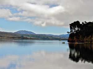 Tomales Bay State Park: Everyone’s favorite beaches
Tomales Bay State Park, Marin’s third state park, turns 60 this year. This story goes back to the earliest days of MCL in 1935 when the alarm was sounded by local residents who feared the beaches of Tomales Bay might be lost to the public A serious attempt to save the beaches didn’t begin until around 1942, however. Local residents began organizing to secure the beaches for park purposes, and MCL “adopted” the project, with Bruce Johnstone, Inverness, and Caroline Livermore, co-founder of MCL, playing pivotal roles.![]()
Their first success was matching the County’s contribution to acquire 185 acres at Shell Beach as a County park in 1945. With the State as eventual target, Johnstone and Livermore continued to pursue the County to match State funds for additional acquisitions. With the help of the Sierra Club, Alpine Club, TCC, Marin Nature Group, several garden clubs and other organizations, five sandy beaches (Indian, Upper Pebble, Lower Pebble, Heart’s Desire, Shell), two miles of waterfront, and acres of Bishop Pine forest became Tomales Bay State Park.
On November 8, 1952, MCL hosted 200 people to celebrate the new State Park and to dedicate the Willis Linn Jepson Memorial Grove of Bishop pines. The Park subsequently was enlarged to 2,400 acres with the addition of three parcels on the opposite (east) shore of Tomales Bay. And in 1980, the Johnstone Trail was completed, connecting all the west park’s beaches. That was the year Carlos Porrata began his 24-year service as resident Ranger for the Park, among many other activities, imparting the legends of Native American inhabitants of Tomales Bay to thousands of elementary school children. In his retirement years, Carlos is helping to keep the State Parks in Marin open and their legacy alive!
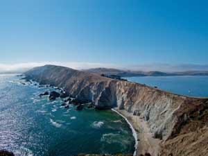
Point Reyes National Seashore: A wilderness within easy reach
Point Reyes National Seashore is celebrating 50 years. The idea of making the Peninsula into a national park was first proposed in 1935 by the National Park Service, but in the late 1950s it became the dream of Marin Congressman Clem Miller. Miller, who owned a home in Inverness, was chief author of the bill that created the Seashore and was signed into law by President Kennedy in September 1962. Harold Gilliam’s classic elegy about the Peninsula, “Island in Time,” may also have played a role in its preservation: as a key tactic of the campaign, the Sierra Club placed a copy of the book on the desk of every member of Congress that year. In the book, Gilliam wrote: “We need to keep some of our vanishing shoreline an unspoiled place, where all men, a few at a time, can discover what really belongs there—can find their own Island in Time.”
A month later, Clem Miller died in a plane crash. With insufficient funds to purchase lands and rising land prices, the Park Service by 1969 was ready to sell off some of the land for private development. Peter Behr intervened and led a massive Save-Our-Seashore campaign to send a half-million letters to then-President Nixon to free-up Land and Water Conservation Funds to complete the park. “ . . Probably no park area anywhere has gone through more traumas or has depended more on the work of legions of volunteers than this one.” (Gilliam, “Island in Time,” 2nd Edition, 1973).
These days, John Dell’Osso thinks he may have the best job in the world. In his position as Chief of Interpretation and Resource Education at Point Reyes National Seashore, he tells adult visitors and school kids about this Island in Time. He begins by describing the size and diversity of the park’s holdings—more than 71,000 acres, including 33,000 acres of wilderness area proposed by citizens, including MCL, 80 miles of unspoiled coastline, and management of another 21,000 acres of adjacent Golden Gate National Recreation Area lands. More than two million people annually visit the park’s estuaries, beaches, coastal grasslands, salt marshes, and coniferous forests.
The park together with the Gulf of the Farallones and Cordell Bank National Marine Sanctuaries, Tomales Bay State Park, MMWD lands, and GGNRA constitute one of the few remaining biologically diverse Mediterranean climate regions on earth, earning recognition by the United Nations (UNESCO) Man and the Biosphere program and as part of the Central California Coast Biosphere Reserve. The peninsula is also rich in its 2,000-year cultural history, beginning with the Coast Miwok Indians, the first human inhabitants.
In view of the early battles to preserve the park from inevitable despoliation, Dell’Osso likes to quote David Brower, former Executive Director of the Sierra Club, who warned: “The Peninsula is what we have and there is no more where it came from.” Fifty years later, we can celebrate the prescience of those who persisted in fulfilling Clem Miller’s dream!
Golden Gate National Recreation Area: saving the Marin Headlands
Golden Gate National Recreation Area, the Bay Region’s second great national park, was authorized by President Nixon ten years later, in 1972. No one knows the story of GGNRA better than Amy Meyer, who walked into a San Francisco neighborhood controversy one evening in 1970 and ended up co-chairing the campaign for a new national park. Amy recalls a critical moment in the struggle to gain the park:
“Congressmen Phillip Burton, Bill Mailliard and Don Clausen were celebrating on October 11, 1972 when they phoned me from Washington, shouting that the GGNRA legislation had finally passed the House. There was no worry about Senate passage. President Nixon would sign the bill, part of his ‘Legacy of Parks.’
I could hardly believe two years of non-stop effort had ended. Our ad-hoc group, People for a GGNRA, had taken a government plan for 8,000 acres and pushed it to 34,000. Much of that increase was made possible by work done by early Marin residents and MCL: we could connect public land from the Marin headlands to Point Reyes. People for a GGNRA Chairman Edgar Wayburn guided policy; I was co-chair and guided volunteers. Bob Raab of MCL became our Marin chairman. Bob Young, also of MCL, created our maps.
Today the park encompasses 80,000 acres in three counties, and has become what I could not imagine that evening. Miles of chain-link fencing were removed, acres of exotic foliage were replaced with native habitat, and historic buildings were rehabilitated. Our first superintendent, Bill Whalen, kept public participation alive through the Advisory Commission for GGNRA and Point Reyes and pioneered development of private partnerships for parks. Just look at the trails, visitor centers, kiosks, and brochures done by the Golden Gate National Parks Conservancy! Park programs are available for everyone, from children to seniors.
‘Parks to the people, where the people are’—in urban areas—was our rallying cry. Every time I visit the park, I know we succeeded.”
Frank Dean, General Superintendent of GGNRA, agrees: “The citizen-led conversion of these spectacular lands from national defense to ‘natural defense’ is so characteristic of the Bay Area culture. Today our relationship with the community provides many opportunities, and we are fortunate that these parks are valued as an integral part of the quality of life in our region.”
Marin County’s Open Space Preserves: special lands in Marin’s “back yard”
1972 was also the year Marin County voters established the Marin County Open Space District, now Marin County Parks. The timing was right! The beginning of the 1970s was a period of profound awakening in Marin. Marincello had been defeated, as had the plan to cover West Marin and connect to 101 with an east-west freeway. The County’s 1971 landmark planning study, “Can the Last Place Last?” outlined the pressures for sprawling urban development and new highways that threatened to change fundamentally Marin’s physical appearance and environmental quality.
On one local front, the alarm of Mill Valley residents who saw nearby ridges of Mt. Tamalpais being slated for development grew into a community effort to save North Ridge. Citizens rallied, lobbied, and ultimately convinced the voters to pass Measure A, thus assuring a stream of tax dollars to fund acquisitions of lands as open space throughout the County.
Pierre Joske, Director of Marin’s Parks and Recreation Department for 17 years and recently deceased, had his own version of the origins of the Marin County Open Space District. He recalled that two women from the Marin Conservation League came into his office in the Civic Center one day in 1971, sat down on his desk, and demanded: “This County has got to have a regional system of public parks and open spaces!” —or something to that effect. Whatever the exact words, Joske was persuaded to spearhead the formation of what became the Marin County Open Space District, later renamed Marin County Parks, with Joske as its chief and Brian Wittenkeller as its first planner. Dave Hansen joined the growing District two years later and now, in his retirement, recalls the rich experience of learning under Joske’s leadership in those early years.
Under Joske’s management, the District acquired thousands of acres of ridgetops and rolling hills, flowing streams, coastlines, and over 200 miles of trails. Over four decades, Marin County Parks has continued to acquire hundreds of undeveloped parcels from willing sellers, totaling more than 20,000 acres. Much of this acreage became open space preserves—now 34 in total. The preserves are complemented by four regional parks, as well as many active sports facilities, picnic areas, and paths.
Today, Katherine Mindel Jones (“Kat”) and other young County Parks staff represent a new generation poised to continue the legacy of land stewardship in Marin. Kat is the Coordinator of External Affairs for Marin County Parks. An attorney by training, she has the enthusiasm and vision of someone who looks forward to many years of commitment of service to the environment. For Kat and her generation, there will be new responsibilities if the parklands and open spaces that preserve Marin’s natural environment for fish and wildlife and for people to enjoy are to endure.
Point Reyes peninsula photo courtesy and copyright Bob Grace. Tomales Bay photo courtesyTim Rosenfeld.
Back to Newsletter
Become a Member
 |
 |
Help support the Marin Conservation League and protect and preserve Marin County's beautiful natural assets. Join us now or renew your membership today!