| Marin Conservation League | 175 N. Redwood Dr., Ste. 135 | San Rafael CA 94903 | Tel 415.485.6257 | Fax 415.485.6259 Email Us. |
 |
150 Shoreline
Tamalpais Valley
150 Shoreline Project raises question of sea level rise
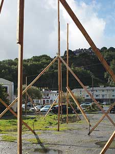
 In any other location, the proposal by Southern Oil Company to construct a 5,913 square foot building grocery store and delicatessen with three second-floor condominium residential units (one of them affordable) on a roughly half-acre disturbed site would be considered totally appropriate. The level site north of Shoreline Highway in the Manzanita area of the unincorporated community of Tamalpais Valley was originally developed as a gasoline service station, which was removed in 1994. A shared driveway from Shoreline Highway provides access to other commercial uses, including Frantoio Ristorante, a hotel and a two-story complex of small offices.
This particular location raises some issues that are indicative of the need for policies that the County and Bay shoreline communities of Marin will have to consider in coming years—development in areas subject to sea level rise. The 25,557 square foot property is on filled marshland of Richardson Bay, approximately 400 feet south of the tidal Coyote Creek and 500 feet southwest of the Bay shoreline. During a recent period of high tides, the site was flooded, a chronic condition in the area. Marin Conservation League is concerned that the project is proposed in an area of existing flood hazard, which will be exacerbated by sea level rise, and that existing policies do not fully address this future condition.
The Negative Declaration for the project states the following: “The design of the project would provide a finished floor elevation above the top of the slab at 13.08 feet NAVD (roughly equivalent to Mean Sea Level) where the ground elevation will be leveled to 9.7 feet NAVD. The height of the finished floor would account for settlement of the structure within 100 years and would maintain compliance with the 100-year base flood elevation Sea level rise will likely change the base flood elevation over this time frame, and it is recommended that the building design include adjustable connections to the foundation to allow for raising the structure above the base flood elevation after long-term settlement and sea level rise. No significant effects.”
Although this previously developed site is surrounded by other buildings, and the proposed use is consistent with applicable plans, the proposal raises issues that jurisdictions fronting the Bay are going to have to start addressing in a broader way. The County, working with other Marin jurisdictions on the Bay and working with data that has been compiled by the Bay Conservation and Development Commission, should initiate studies to determine where sea level rise is most likely to affect low-lying areas, and what comprehensive planning policies should address these changes. Properties surrounding Richardson Bay are particularly vulnerable. It is not enough to mitigate the impacts of individual projects; these mitigations could have broader off-site impacts. MCL has commented on this particular project because we see it as an example of future potential county and community problems.
Documents and Correspondence
2011


