| Marin Conservation League | 175 N. Redwood Dr., Ste. 135 | San Rafael CA 94903 | Tel 415.485.6257 | Fax 415.485.6259 Email Us. |
 |
![]()
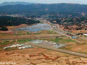
Gnoss Field
Runway Extension
The Marin County Board of Supervisors will consider the merits of the proposed 1,100-foot runway extension for the Gnoss Field Airport Runway 13/31 at its regular meeting on Tuesday, August 19, 2014, 2:30 pm, Room 330, Marin County Civic Center.
Background:
Environmental review for Gnoss Field runway extension is finally nearing conclusion with the release of the Final Environmental Impact Report (FEIR) in November 2013 and the Final Environmental Impact Statement in July 2014. The planning process began in 1997 when an Airport Master Plan was adopted by the county along with a Program EIR. Some changes were made to the airport facilities after that, but no other EIRs were done until it was decided to extend the runway 1100 feet for operational reasons. Many issues identified by agencies, organizations and individuals in the Draft EIR/EIS have been responded to in the recent Final EIR/EIS. MCL is currently reviewing the Final EIS.
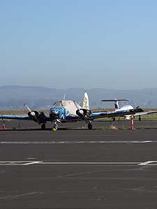
Extending the runway 1100 feet will create a 4400 foot runway, which was adopted in the Countywide General Plan in 2007. It was determined that a 4400 foot runway is needed because the “critical aircraft” of the fleet of airplanes based at Gnoss Field is a Cessna 525, which cannot operate efficiently on a 3300 foot runway. On warm days the Cessna 525 cannot take off with a full load of either passengers or fuel from Gnoss Field. That necessitates landing at another airport to load additional fuel or passengers. The nearby airports with runways longer than 3300 feet are Sonoma County Airport and Napa Airport.
The DEIR reviewed three alternatives: Alternative A, the No Project; Alternative B, 1100 feet added to the northwest end of the existing runway (Preferred alternative); and Alternative D, adding 240 feet to the southeast end of the runway plus 860 feet to the northwest. The United States Environmental Protection Agency (EPA) recommended analysis of runway shorter than 4400 feet.
Since the extension would require filling wetlands on the low-lying airport site, MCL wrote to encourage that the filling of wetlands be mitigated close to the airport and not in other counties miles away from the area of impact, as recommended in the EIR. MCL also requested that the potential changes in the composition of aircraft fleet be discussed and associated impacts analyzed. Other issues raised by MCL included the need to consider the impact of sea level rise on the extension, as well as impacts on local water quality in near-by Petaluma Marsh and San Antonio Creek, and noise impacts and operational safety. Most of these issues were addressed adequately in the Final EIR. The Final EIS was released in June 2014 and final approvals are pending.
 Gnoss Field lies within the original floodplain of the Petaluma River, whose wetlands comprise the largest remaining intact salt marsh system in the San Francisco Bay Region. The original airport dates from 1939, when a grass landing strip was built on the diked field. Since that time, as the airport has expanded to its current condition, levees and drainage channels with pumps have played an essential role in preventing the facilities from flooding.
Documents and Correspondence
June 9, 2016 - MCL Comments on Extension of Runway 13/31
December 9, 2013 - MCL comments on Gnoss Field Final EIR
February 6, 2012 - MCL comments on Gnoss Field EIR/EIS
August 27, 2008 - MCL comments on Gnoss Field Scoping
Photo by Bob Minkin
Become a Member
 |
 |
Help support the Marin Conservation League and protect and preserve Marin County's beautiful natural assets. Join us now or renew your membership today!